-
15 abr 2024Minería y metalurgiaGeochemistry Part I: What is metal leaching and acid rock drainage (ML/ARD), and how does it occur?
-

Todd McCracken
Department Manager | Mining and Geology
-
-
25 mar 2024Minería y metalurgia
What we know about processing nitrogen compounds in mining effluents
-
-
04 mar 2024Otras IndustriasOptimizing solutions for air quality and acoustics in industrial settings
-
-
29 feb 2024Energía eléctrica y renovablesAn integrated and strategic approach to decarbonize industrial compagnies
-

Stéphane Charest
Vicepresidente de Mercado de Energía y de Productos Químicos
-
nov 27, 2019
How to properly prepare your data for a mineral resource estimate?
In most cases, when we receive a client database to perform 3D modelling or run an NI43-101 compliant resource estimate (or JORC), the data is incomplete or may contain errors.
The following are examples of steps you can take before sending your database to modelling or resource geologists, either internally or to an independent firm to save time.
-
Drill hole data
- Drilling location data, as well as deviation, lithology and assays data, are essential elements for creating a robust geological model and providing an unbiased estimate of mineral resources. This data must therefore be validated to be sufficiently rigorous, reliable and complete to comply with the NI 43-101 (or JORC) standard. As a result, data traceability is mandatory to comply with those standards. You will have to provide the qualified person (QP) with your drilling, sampling and QA/QC procedures as well as the raw data (survey and assay certificates, deviation data) from the professional surveyor and the laboratory directly. All drill collars should be surveyed by a professional surveyor.
- QA/QC data will also be reviewed by the QP. Make sure the QA/QC results are valid and that the certificates for failed QA/QC have been re-analyzed (or that the error is explainable) and that QA/QC data is complete.
- Specific gravity data is also crucial for mineral resource estimates. Make sure they are representative of each lithology and type of mineralization and that the data is dense enough. Waste density is also important because it will determine how much waste tonnage should be removed to reach mineralization.
- Wedge holes and hole extensions must be clearly indicated in the database to avoid bias in the resource due to missing implicit intervals. Likewise, the pending assays must be flagged.
- Some projects use data collected in several different coordinate grids (mine, local, UTM, MTM, etc.). If this is the case for your project, make sure these systems are orthogonal and if not, make the necessary azimuth corrections. If a conversion exists across the various coordinate systems, it is important to have it validated by a professional surveyor and to provide the conversion to the QP.
Other important information
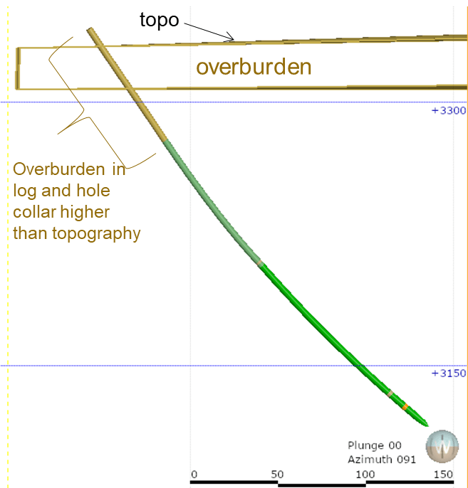
- A topographic surface must also be provided. Validate that the elevations of the drillholes are consistent with the topography. In the absence of a “LiDAR” topographic surface, drill collars can be used to build a surface. However the level of accuracy of such a surface is not as good as a professional survey like the “LiDAR”.
- During the mineral resources estimate, overburden modelling will have to be carried out, particularly for open-pit mining projects. Make sure your lithology data includes a field for the overburden.
-
-
- In the case of a project that has been mined in the past, it will be essential to provide the voids (drifts, raises and stopes) and a thorough topography surface of the open pits.
- Finally, other information such as the contours of the mining titles and the hydrographic and toponymic network will also have to be delivered.
Understanding of the project
- Exploration geologists are usually the people who know the project geology best. It is therefore strongly recommended that they complete at least a few sections with their interpretation to help modelling geologists create a realistic geological model, and they need to be involved regularly in the modelling.
- For historical projects, providing historical plans and sections can save a considerable amount of time for modelling and increase model accuracy, since they take into account all the work performed by geologists who have worked on the project over time.
Conclusion
From the earliest stages of exploration and throughout the project, it is important to focus on validating and integrating the database to avoid wasting time and money. Our team of experts can support you throughout all your exploration and mining projects, from data acquisition, interpretation and modelling to estimation and optimization of resources and reserves.
If you have any questions or want to learn more about this topic, feel free to contact us.
This content is for general information purposes only. All rights reserved ©BBA


